


FishTrack - Fishing Charts
3.533.00 Reviews
App Specs
- Version
- 1.5.1
- Updated On
- License
- Free
- Downloads
- 100,000+
- Developer
- Surfline/Wavetrak, Inc.
- Categories
- Weather
- Platform
- Android
Screenshots
 Analysis by AppCompare
FishTrack makes the most sense when I think of it as a planning aid for time on the water, not a promise that a particular patch of ocean will produce a catch. Its appeal is the chance to bring marine conditions and fishing charts into one place, so I can compare what the water is doing before deciding where to go. That is a useful idea for anglers who already pay attention to conditions, but it is less compelling if all I need is a basic forecast for a walk along the shore.
What trust looks like for a marine-planning app
With any tool I might check while preparing for a boat trip, trust is practical: I want to understand what I am looking at, make my own call, and avoid treating an app as a substitute for good judgment. FishTrack is a weather app from Surfline/Wavetrak, Inc., built around fishing charts, route planning and marine forecasts. That focus gives it a more specialized role than a standard weather app, but the charts are still information to weigh alongside local knowledge and conditions on the day.
I also think it is worth separating useful detail from certainty. A chart can help me spot patterns and compare areas; it cannot guarantee that fish will be present or that a planned route will be safe. For a trip, I would use it to inform preparation, then check conditions again before leaving and keep a separate way to navigate. That cautious approach matters especially offshore, where a phone’s signal, battery and display are not things I would want to rely on alone.
Choices, costs and a sensible first check
The app is free to download, and it has in-app purchases listed from $14.99 to $95.88 per item. I would start by looking at what is available inside the app and deciding whether those options match the way I fish before spending anything. If I only make occasional coastal trips, the free starting point may be enough to see whether the chart-based approach suits me; regular offshore anglers may have a stronger reason to explore paid options, but should still compare the value with their actual routine.
FishTrack has a 3.5 average from 357 ratings, with 34 written reviews, and more than 100K installs. I take those figures as context, not as proof that the app will work equally well for every phone or fishing area. It is rated for Everyone, and version 1.5.1 requires Android 7.0 or later. Before planning a trip around any app, I would check that my device can run it and try it at home, where I can learn the controls without time pressure.
Where it fits in an angler’s routine
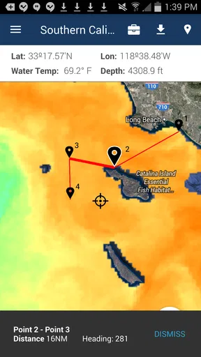
A concrete use for FishTrack is comparing candidate areas the evening before a trip. I can review the marine picture, think through a route, and note which conditions I want to recheck in the morning. That is more useful than opening a weather app once and treating a single number as the whole forecast. It also gives me a reason to make a backup plan: if the conditions change, I have already considered another area rather than improvising at the dock.
My practical tip is to separate planning from navigation. A route-planning screen can help organize an intended outing, but I would not assume that this alone replaces a dedicated navigation device, nautical charts, or a skipper’s local knowledge. I would also avoid making a last-minute decision based on one chart layer. Looking at several relevant conditions together can give a more rounded picture, while checking a trusted forecast close to departure helps catch changes that an earlier plan cannot account for.
Worth Reading Before You Choose

EA SPORTS FC Mobile 26 Is a Bigger Football Game, but It Takes Time

Flipboard Shows What News Apps Must Do Beyond the Feed

Switching to Android Auto Means Rethinking Your Driving Routine

Google Calendar Makes a Crowded Week Easier to Manage

Ludo King Makes the Most of the Minutes Between Plans

Baby Panda World Brings Quick Play to Modern Phones, but Its Game Library Feels Busy
That distinction helps explain who is likely to get the most from it. Anglers who choose offshore or coastal spots by comparing marine conditions have a clearer reason to use a specialized chart tool than someone who fishes a familiar pond and mainly wants rain alerts. If I were a casual shore angler, I would probably begin with a general weather app and local reports. If I regularly plan routes over open water, FishTrack’s marine focus is more relevant, though I would still keep other safety and navigation resources in the mix.
Using FishTrack with care and confidence
When I first opened FishTrack - Fishing Charts, I was pleasantly surprised by how clean and intuitive the interface is. The developers clearly put a lot of thought into making the app user-friendly. The home screen offers a dashboard that gives you all the critical information at a glance. Everything from sea surface temperatures to cloud cover is neatly organized, making it easy to navigate even if you’re not tech-savvy.
The app’s layout is quite straightforward. You’ve got your main menu at the bottom, which allows quick access to charts, weather updates, and other essential features. I really appreciated the quick tutorial that pops up the first time you use it, guiding you through its primary functions without overwhelming you with too much information at once.
Key Features: What Makes It Stand Out?
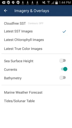
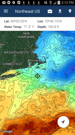
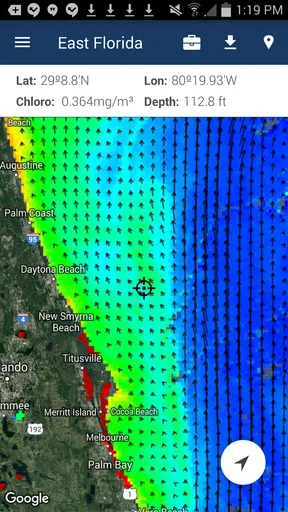
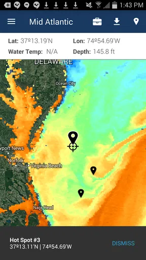
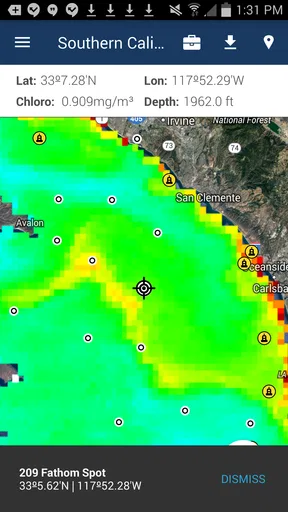
One of the standout features of FishTrack is its satellite imaging. By providing real-time data on sea surface temperatures, chlorophyll levels, and altimetry, the app helps you pinpoint the best fishing spots. This data is invaluable, especially if you’re targeting specific species that prefer certain water conditions.
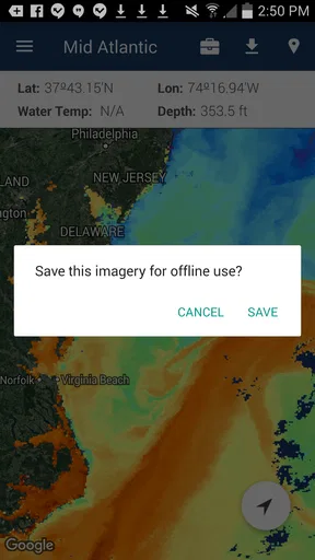
Another feature that I found incredibly useful was the offline charting. I mean, we’ve all been there—out at sea with no cell signal, right? FishTrack lets you download charts for offline use, ensuring you’re never left in the dark when it comes to planning your fishing strategy.
Plus, the app integrates weather forecasts, including wind speed, direction, and tide info. Having all this data in one place makes it easier to plan your trips ahead and decide whether it's worth getting up at the crack of dawn or waiting for better conditions.
Reading charts without over-trusting them
The most useful way I see these layers is as clues to compare, not a magic marker on a guaranteed hotspot. Sea temperature, chlorophyll and altimetry can help me think about where conditions differ, but interpreting them takes some care: a promising-looking patch does not tell me exactly what is beneath the boat, and the species I am after still matters. I would use the chart to narrow a search area, then adapt to what I observe and to advice from people who know that water.
There is also a small workflow choice that can make a real difference: I would decide which chart views matter before heading out, rather than trying to inspect everything while underway. Saving the relevant charts in advance makes the offline option more useful and reduces the temptation to troubleshoot on the water. Downloads are only helpful if I have selected the area I actually need and allowed time to prepare, so I would make that part of the night-before routine.
Offline access is not the same as a complete offline safety system. It can preserve chart information when a connection is unavailable, but I would not infer that every live forecast or changing condition will keep updating without service. Before leaving coverage, I would check current conditions, save what I expect to consult, and keep a separate navigation backup. That trade-off is important for anyone heading far enough offshore that a lost connection could affect more than convenience.
Forecasts, timing and everyday decisions
For a realistic day, imagine I am deciding whether to launch early before work or wait until later. I can use the marine forecast to compare wind direction, wind speed and tide information, then weigh those against the route and the kind of fishing I plan to do. The point is not to let the app make the decision for me; it is to replace guesswork with a more organized check. If the forecast looks less favorable than expected, I can shorten the outing, choose a more sheltered plan or stay ashore.
Compared with a general weather app, FishTrack is aimed at the water and at anglers who care about chart context rather than just whether it will rain. A standard forecast may be quicker for checking local conditions, and a dedicated navigation tool may be the better choice when precise navigation is the priority. FishTrack sits between those needs: it can help with fishing-oriented planning, but I would not ask it to replace a full marine navigation setup or my own safety checks.
Performance and Reliability
In terms of performance, FishTrack holds up remarkably well. I’ve used it on a couple of trips now, and it hasn’t let me down. The app loads quickly, and the charts update in real time without any noticeable lag. Even when using the offline charts, the app remains responsive and provides all the information I need without a hitch.
Battery consumption is always a concern with such feature-rich apps, but FishTrack does an impressive job of managing resources. I’ve spent whole days on the water, and the app doesn’t drain my phone’s battery as quickly as some other apps I’ve tried.
Even so, I would not make battery life a reason to leave a charger or backup power at home. Screen brightness, signal searching and extended map use can all affect a phone during a long outing, and marine conditions make a depleted device inconvenient at best. I would download charts while connected, dim the screen when practical and carry a power option. That is a sensible habit for any phone-based tool, not a criticism unique to FishTrack.
Account choices and data-sensitive moments
On the privacy side, I prefer to make decisions based on controls I can actually see rather than assume what an app collects or shares. I would review the permissions requested during installation and use, and only grant access that makes sense for the task I am trying to do. If I am just exploring charts at home, I can be deliberate about whether a permission is needed at that moment instead of tapping through automatically.
Fishing locations can be sensitive for practical reasons, even when a person is not worried about privacy in general. I would think twice before posting a catch or route publicly if it could reveal a spot I want to keep to myself. Where the app presents sharing choices, I would check the audience and content before confirming; where I do not need a social function, I would simply avoid sharing. This is a useful habit with any fishing community, not a claim about a particular setting.
The app’s version is 1.5.1, so I would also take a moment to check that it behaves as expected on my device after installing or updating. A quick test at home can answer the practical questions that matter to me: can I find the charts I want, can I prepare an offline area, and are the screens readable on my phone? Testing before a trip gives me room to adjust without relying on last-minute support or a weak connection.
Community and Support
One of the pleasant surprises with FishTrack is the active community of users. The app includes a social component where you can share your catches and tips with other anglers. It’s a great way to learn from others and maybe even pick up some secret spots!
The support offered by the developers is also top-notch. They seem genuinely interested in user feedback and frequently update the app to fix bugs and introduce new features. On the few occasions I’ve had questions, their response was swift and helpful.
Who should choose it—and who should not
I would recommend giving FishTrack a try if fishing decisions depend on comparing marine conditions and you want charts and forecasts in the same planning routine. It is especially relevant when I am considering more than one offshore or coastal area and need a structured way to think through the choice before launching. Someone who mainly wants a simple rain forecast, or who expects a phone app to provide dependable navigation on its own, is better served by a different primary tool.
A useful first session does not need to happen on the water. I would open the chart views at home, identify the area I expect to fish, and check how the layers help me reason about it. Then I would prepare the offline charts I may need and compare the forecast again close to departure. If the interface or chart information does not answer the questions I actually ask when planning, there is little reason to pay for extras or make it part of every trip.
Final Thoughts
So, is FishTrack worth downloading? In my opinion, absolutely. Whether you’re a seasoned angler or just starting out, this app provides a wealth of information and tools that can enhance your fishing experience. Its combination of real-time data, offline capabilities, and community features make it a standout choice in the crowded market of fishing apps.
Overall, FishTrack - Fishing Charts is a game-changer for anyone serious about fishing. It’s like having a secret weapon in your tackle box. So next time you’re planning a trip, give it a shot. Who knows? You might just land the catch of a lifetime!
Pros
- Detailed ocean maps enhance fishing experience.
- Real-time weather updates are highly accurate.
- User-friendly interface for easy navigation.
- Offline mode available for remote locations.
- Customizable waypoints improve trip planning.
Cons
- Limited features in free version.
- Requires stable internet for updates.
- Some maps are not regularly updated.
- Battery consumption is relatively high.
- Occasional app crashes reported.
FAQs for FishTrack - Fishing Charts
What features does FishTrack - Fishing Charts offer?
FishTrack provides detailed sea surface temperature charts, chlorophyll maps, and current altimetry data to help anglers locate fish hotspots. The app also includes real-time weather updates, tide information, and a comprehensive fishing log. Users can save fishing spots and access them offline, making it a versatile tool for serious anglers.
Is FishTrack available for both Android and iOS?
Yes, FishTrack - Fishing Charts is available for download on both Android and iOS platforms. Users can find the app on the Google Play Store for Android devices and the Apple App Store for iOS devices. Ensure your device meets the minimum OS requirements for optimal performance.
Does FishTrack require an internet connection to function?
While FishTrack offers offline capabilities for saved charts and fishing locations, an active internet connection is required to download new maps and receive real-time weather updates. It's advisable to download necessary data before heading out to areas with limited connectivity.
Are there any subscription fees for using FishTrack?
FishTrack offers a free version with basic features, but for advanced functionality like high-resolution charts and additional weather data, users may need to subscribe to a premium plan. Pricing details can be found in the app or on the official FishTrack website.
How accurate is the data provided by FishTrack?
FishTrack sources data from reliable providers, ensuring high accuracy in its charts and weather updates. However, users should always cross-reference with local conditions and updates. The app is designed to assist in planning but should be used in conjunction with real-world observations.


